
Data & Tools:
Google Earth Engine, Sentinel-2 Time-Series Data, NDVI, EVI, SAVI, GCVI, NDWI, LAI, PythonSkills & Knowledge Gained:
- Time-series analysis with satellite imagery
- Vegetation index calculation (NDVI, EVI, etc.)
- Data interpolation and cloud masking in satellite data
- Signal smoothing with moving averages
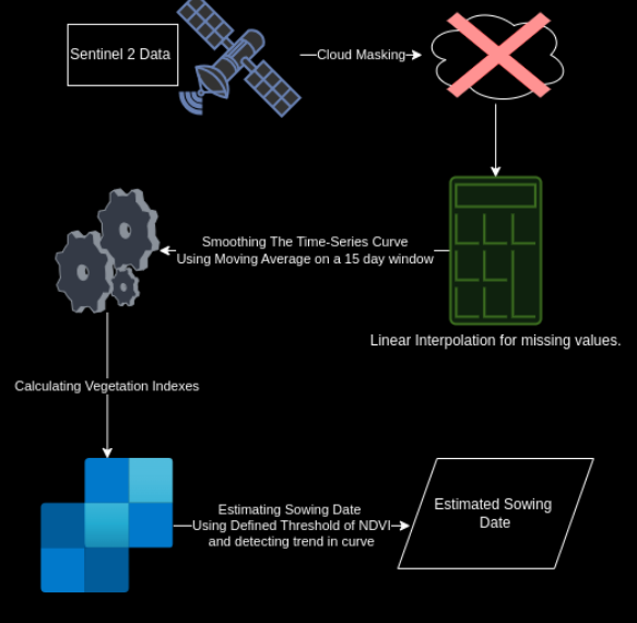
This project leverages Sentinel-2 time-series data to estimate the optimal sowing date for crops. Instead of using machine learning, we performed a detailed time-series analysis. The workflow involved cloud masking and smoothing the data using a 15-day moving average window, followed by calculating key vegetation indices. Finally, we applied threshold criteria to estimate the sowing date.
Methodology Diagram
Explore the Sowing Date Estimation Tool
Below is the embedded Google Earth Engine (GEE) app that demonstrates my approach using Sentinel-2 data. You can explore the app and interact with the analysis directly in your browser.
Explore the Project Code
Dive into the project’s code and learn more about how we used Sentinel-2 data for sowing date estimation.
Key Insights & Observations
The time-series analysis of vegetation indices provided valuable insights into crop planning. By applying smoothing techniques and threshold criteria, we were able to derive timely, accurate estimates for sowing dates, enabling better precision in agricultural decision making.
Employing satellite imagery for estimating sowing dates has shown significant potential in enhancing agricultural planning. By automating parts of the analysis using a time-series approach, this project offers a more efficient method to monitor crop development and optimize sowing strategies, ultimately leading to improved resource management.