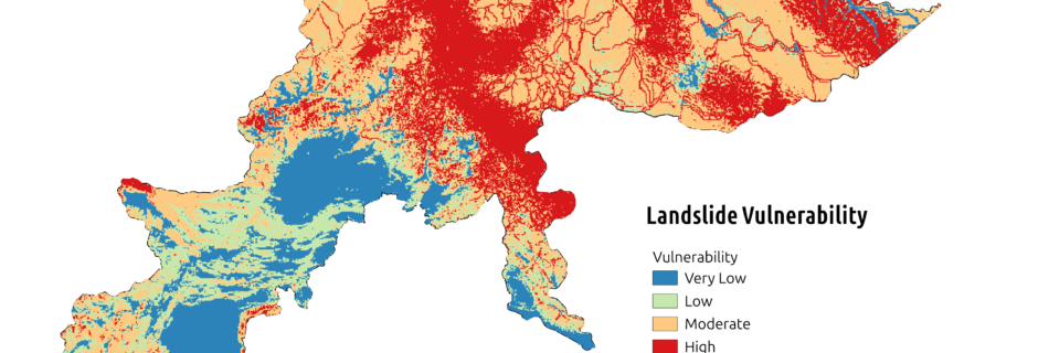
A multi-criteria assessment of landslide susceptibility, infrastructure gaps, and population density in Khyber Pakhtunkhwa (KPK), Pakistan. Data & Skills Data & Tools: NASA’s LHASA 2.0 Landslide Data, WorldPop, HOTOSM Roads, QGIS, Python (Network Analysis) Skills & Knowledge Gained: Study Overview This study evaluates community vulnerability to landslides in Khyber Pakhtunkhwa (KPK), Pakistan, focusing on the interplay …
Read more “Infrastructure-Weighted Analysis of Population Vulnerability to Landslides”
Overview This project explores migration dynamics across Estonia&aposs territorial communities in 2018, highlighting key urban centers and tracing migratory flows influenced by job opportunities, lifestyle changes, and social networks. Design & Execution Beyond data analysis, the map serves as an example of artistic cartography. It combines advanced GIS techniques with creative visualization to transform raw …
Read more “Movement Between Territorial Communities in 2018, Estonia”
Unraveling the dynamics of Colored Dissolved Organic Matter (CDOM) and Optical Water Types (OWT) using cutting-edge satellite data and advanced machine learning techniques. Study Overview Discover the dynamic interplay between Optical Water Types and Colored Dissolved Organic Matter in Lake Võrtsjärv. Leveraging cutting-edge Sentinel-2 imagery, real-time meteorological data, and advanced machine learning, this study reveals …
Read more “Spatio-Temporal Changes in Optical Water Quality Parameters”
Data & Tools: Skills & Knowledge Gained: This project leverages Sentinel-2 time-series data to estimate the optimal sowing date for crops. Instead of using machine learning, we performed a detailed time-series analysis. The workflow involved cloud masking and smoothing the data using a 15-day moving average window, followed by calculating key vegetation indices. Finally, we …
Read more “Estimating Sowing Dates using S2 Time-Series”
Skills & Knowledge Gained: This project focuses on visualizing 3D point cloud data in an interactive 3D environment using CesiumJS. By embedding Cesium’s powerful geospatial capabilities into a web interface, this application allows users to explore complex 3D point data, such as urban models, terrain features, and sensor data, directly within their browsers. Explore the …
Read more “Visualizing 3D Point Cloud Data using Cesium”
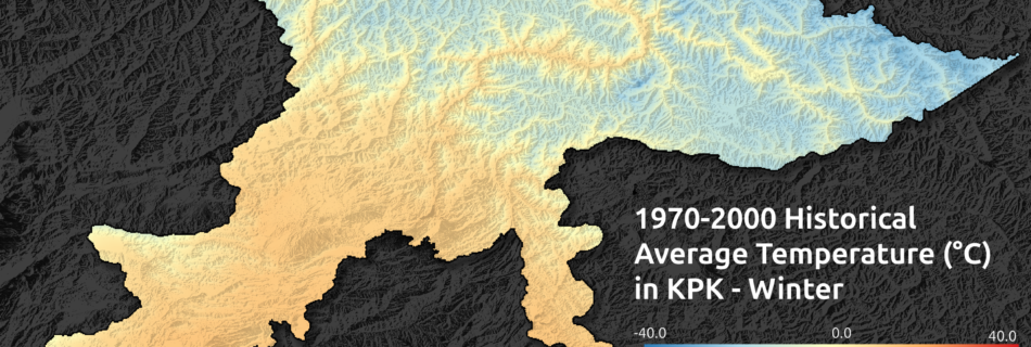
Analyzing Seasonal Dynamics in KPK Tools Skills & Knowledge Gained This project investigates the climatic patterns in Khyber Pakhtunkhwa (KPK), a region in northwestern Pakistan characterized by a diverse topography—from high mountainous areas to vast plains. By analyzing datasets spanning several decades (1970–2000), the study examines seasonal variations in temperature, precipitation, and solar radiation. This …
Read more “Global Climate Data”